Help keep this website running!
Postcard
PayPal
Bitcoin
|
This page is community maintained. The information is intended for PC simulator navigation or reference. Always use approved charts for navigation.
Private use. Permission required prior to landing.
Sandwich, Massachusetts, United States (2542)
Lat/Lng: | 41° 39' 32.9" N / 70° 31' 22.1" W
41.659139 / -70.522806 |
---|
Elevation: | 130'ft / 40mMSL |
---|
Declination: | W015° | ID / ICAO: | KFMH |
---|
FAA: | FMH |
---|
Runways: | 2 |
---|
Longest: | 14-32 Asphalt 2,897m / 9,504ft |
---|
| |
---|
Airport use: | Private, Permission required |
---|
Controlled: | Yes |
---|
(Edited 2014-05-21) [ Edit disabled ]
Ground: | 121.6 |
---|
Tower: | 121 |
---|
Approach: | 118.2, 118.75, 126.3 |
[ Edit disabled ]
MARTHAS VINEYARD VOR-DME | 18.8 NM |
MVY | freq: 114.50 |
S 194° |
MARCONI VOR-DME | 35.2 NM |
LFV | 114.70 |
NE 45° |
NANTUCKET VOR-DME | 36.6 NM |
ACK | 116.20 |
SE 135° |
PROVIDENCE VORTAC | 47.0 NM |
PVD | 115.60 |
W 275° |
SAN CARLOS DE BARILOCHE VOR-DME | 49.8 NM |
BAR | 117.40 |
SW 223° |
|
BOMDE NDB | 6.6 NM |
FM | freq: 362 |
NE 39° |
BOMDE NDB | 6.6 NM |
FM | 362 |
NE 39° |
OTIS NDB | 6.6 NM |
FMH | 362 |
NE 39° |
BOGEY NDB | 17.0 NM |
HY | 342 |
E 76° |
NEFOR NDB | 25.7 NM |
EW | 274 |
W 264° |
NAUSET NDB | 27.7 NM |
CQX | 279 |
E 85° |
TAUNTON NDB | 29.5 NM |
TAN | 227 |
NW 300° |
MARSHFIELD NDB | 31.3 NM |
IMR | 368 |
N 345° |
PROVINCETOWN NDB | 32.2 NM |
PVC | 389 |
NE 28° |
WAIVS NDB | 36.7 NM |
AC | 248 |
SE 130° |
MANSFIELD NDB | 42.1 NM |
IHM | 220 |
NW 304° |
ARMIN NDB | 44.1 NM |
AR | 356 |
W 283° |
STOGE NDB | 44.5 NM |
OW | 397 |
NW 315° |
HULLZ NDB | 49.0 NM |
LI | 346 |
NW 335° |
SAN CARLOS DE BARILOCHE NDB | 49.4 NM |
B | 305 |
SW 223° |
|
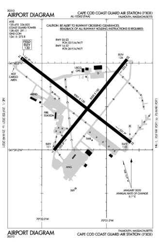
Dimensions: | 2896.8 x 61m 9504' x 200'ft |
Surface: | Asphalt |
---|
Edge Lights: | High intensity |
---|
| Runway 14 [A] | Runway 32 [B] |
Heading: | 142°MH 127°TH | 322°MH 307°TH |
---|
Lat: Lng: | 41° 40' 2.4"N 70° 32' 19.69"W | 41° 39' 5.37"N 70° 30' 40.32"W |
---|
ALS: | | SALS |
Dimensions: | 2430.1 x 61m 7973' x 200'ft |
Surface: | Asphalt |
---|
Edge Lights: | High intensity |
---|
| Runway 05 [A] | Runway 23 [B] |
Heading: | 053°MH 038°TH | 233°MH 218°TH |
---|
Lat: Lng: | 41° 39' 0.12"N 70° 31' 50"W | 41° 40' 1.59"N 70° 30' 43.78"W |
---|
ALS: | | ALSF-I |
|
|