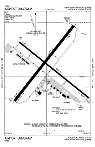
|
This page is community maintained. The information is intended for PC simulator navigation or reference.
Always use approved charts for navigation.

New Bedford, Massachusetts, United States (2745)

| Lat/Lng: | 41° 40' 35.6" N / 70° 57' 28.1" W
41.676556 / -70.957806 |
|---|
| Elevation: | 79'ft / 24mMSL |
|---|
| Declination: | W016° |
|---|
| ID / ICAO: | KEWB |
|---|
| FAA: | EWB |
|---|
| Runways: | 2 |
|---|
| Longest: | 14-32
Asphalt 1,529m / 5,016ft |
|---|
| | |
|---|
| Controlled: | Yes |
|---|
(Edited 2014-05-21) [ Edit disabled ]
| ATIS: | 126.85 |
|---|
| CTAF: | 118.1 |
|---|
| UNICOM: | 122.95 |
|---|
| Ground: | 121.9 |
|---|
| Tower: | 118.1 |
|---|
| Approach: | 128.7 |
|---|
[ Edit disabled ]
| PROVIDENCE VORTAC | 24.6 NM |
| PVD | freq: 115.60 |
W 277° |
| MARTHAS VINEYARD VOR-DME | 26.3 NM |
| MVY | 114.50 |
SE 137° |
| SAN CARLOS DE BARILOCHE VOR-DME | 38.9 NM |
| BAR | 117.40 |
S 197° |
| BOSTON VOR-DME | 47.1 NM |
| BOS | 112.70 |
N 358° |
| SANDY POINT VOR-DME | 47.6 NM |
| SEY | 117.80 |
SW 222° |
| PUTNAM VOR-DME | 49.5 NM |
| PUT | 117.40 |
W 292° |
|
| NEFOR NDB | 4.9 NM |
| EW | freq: 274 |
SW 219° |
| TAUNTON NDB | 14.1 NM |
| TAN | 227 |
N 347° |
| ARMIN NDB | 22.4 NM |
| AR | 356 |
NW 294° |
| MANSFIELD NDB | 25.7 NM |
| IHM | 220 |
NW 331° |
| BOMDE NDB | 26.9 NM |
| FM | 362 |
E 81° |
| BOMDE NDB | 26.9 NM |
| FM | 362 |
E 81° |
| OTIS NDB | 26.9 NM |
| FMH | 362 |
E 81° |
| STOGE NDB | 31.9 NM |
| OW | 397 |
N 344° |
| CENTRAL NDB | 32.1 NM |
| SFZ | 241 |
NW 301° |
| MARSHFIELD NDB | 32.5 NM |
| IMR | 368 |
NE 26° |
| SAN CARLOS DE BARILOCHE NDB | 38.7 NM |
| B | 305 |
S 197° |
| BOGEY NDB | 39.0 NM |
| HY | 342 |
E 85° |
| SAN CARLOS DE BARILOCHE NDB | 41.0 NM |
| OB | 330 |
S 201° |
| MILTT NDB | 41.5 NM |
| BO | 375 |
N 353° |
| HULLZ NDB | 43.3 NM |
| LI | 346 |
N 2° |
| PROVINCETOWN NDB | 46.5 NM |
| PVC | 389 |
NE 54° |
|
| Dimensions: | 1528.9 x 45.7m 5016' x 150'ft |
|---|
| Surface: | Asphalt |
|---|
| Edge Lights: | Medium intensity |
|---|
| Runway 14 [A] | Runway 32 [B] |
|---|
| Heading: | 144°MH 128°TH | 324°MH 308°TH |
|---|
Lat:
Lng: | 41° 40' 49.07"N
70° 57' 50.17"W | 41° 40' 18.34"N
70° 56' 58.59"W |
|---|
| TDZ: | | Yes, lighted |
|---|
| Dimensions: | 1528.9 x 45.7m 5016' x 150'ft |
|---|
| Surface: | Asphalt |
|---|
| Edge Lights: | High intensity |
|---|
| Runway 05 [A] | Runway 23 [B] |
|---|
| Heading: | 054°MH 038°TH | 234°MH 218°TH |
|---|
Lat:
Lng: | 41° 40' 18.08"N
70° 57' 52.26"W | 41° 40' 56.75"N
70° 57' 11.3"W |
|---|
| ALS: | MALSR | MALSR |
|---|
|

 Australia
 Brazil
 Canada
 France
 Germany
 India
India Italy
Italy Russia
 Spain
Spain UK
UK USA
USA


