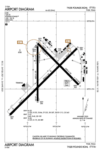
This page is community maintained. The information is intended for PC simulator navigation or reference. Always use approved charts for navigation.
Tyler, Texas, United States (75704)
Lat/Lng: | 32° 21' 13.8" N / 95° 24' 9.7" W
32.353833 / -95.402694 |
---|
Elevation: | 544'ft / 166mMSL |
---|
Declination: | E003° | ID / ICAO: | KTYR |
---|
FAA: | TYR |
---|
Runways: | 3 |
---|
Longest: | 04-22 Asphalt 2,189m / 7,181ft |
---|
| |
---|
Controlled: | Yes |
---|
(Edited 2013-07-28) [ Edit disabled ]
ATIS: | 126.25 |
---|
CTAF: | 120.1 |
---|
UNICOM: | 122.95 |
---|
Ground: | 121.9 |
---|
Tower: | 120.1 |
---|
Approach: | 128.75 |
[ Edit disabled ]
TYLER VOR-DME | 0.1 NM |
TYR | freq: 114.20 |
N 342° |
FRANKSTON VOR-DME | 20.7 NM |
FZT | 111.40 |
S 201° |
QUITMAN VOR-DME | 36.4 NM |
UIM | 114.00 |
N 3° |
GREGG CO VORTAC | 38.2 NM |
GGG | 112.30 |
E 83° |
CEDAR CREEK VORTAC | 49.0 NM |
CQY | 114.80 |
W 256° |
|
INDOO NDB | 5.8 NM |
TY | freq: 320 |
NW 317° |
AMBASSADOR NDB | 23.3 NM |
ABG | 404 |
NE 46° |
ATHENS NDB | 28.4 NM |
AHX | 269 |
SW 241° |
HENDERSON NDB | 33.7 NM |
HNO | 371 |
E 109° |
CHEROKEE CO NDB | 35.2 NM |
JSO | 263 |
S 161° |
VEELS NDB | 36.0 NM |
GG | 410 |
E 78° |
CROSSROADS NDB | 38.1 NM |
CSZ | 215 |
SW 238° |
LOCHRIDGE RANCH NDB | 40.0 NM |
LIQ | 335 |
SW 233° |
PALESTINE NDB | 43.3 NM |
PSN | 375 |
SW 203° |
|
Dimensions: | 2188.7 x 46m 7181' x 151'ft |
Surface: | Asphalt |
---|
Edge Lights: | Medium intensity |
---|
| Runway 04 [A] | Runway 22 [B] |
Heading: | 041°MH 044°TH | 221°MH 224°TH |
---|
Lat: Lng: | 32° 20' 45.4"N 95° 24' 38.48"W | 32° 21' 35.67"N 95° 23' 39.01"W |
---|
TDZ: | | Yes, lighted |
Dimensions: | 1577.2 x 46m 5175' x 151'ft |
Surface: | Asphalt |
---|
Edge Lights: | High intensity |
---|
| Runway 13 [A] | Runway 31 [B] |
Heading: | 132°MH 135°TH | 312°MH 315°TH |
---|
Lat: Lng: | 32° 21' 40.38"N 95° 24' 19.49"W | 32° 21' 3.9"N 95° 23' 36.73"W |
---|
ALS: | MALSR | ODALS |
Dimensions: | 1480.6 x 46m 4858' x 151'ft |
Surface: | Asphalt |
---|
Edge Lights: | Medium intensity |
---|
| Runway 17 [A] | Runway 35 [B] |
Heading: | 177°MH 180°TH | 357°MH 000°TH |
---|
Lat: Lng: | 32° 21' 37.45"N 95° 24' 19.56"W | 32° 20' 49.46"N 95° 24' 19.71"W |
|