Help keep this website running!
Postcard
PayPal
Bitcoin
|
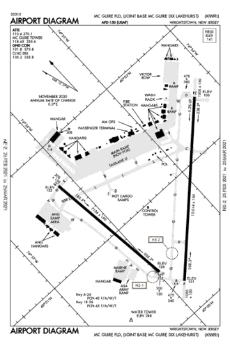
This page is community maintained. The information is intended for PC simulator navigation or reference. Always use approved charts for navigation.
Private use. Permission required prior to landing.
Trenton, New Jersey, United States (8641)
Lat/Lng: | 40° 0' 56.1" N / 74° 35' 30.12" W
40.015583 / -74.5917 |
---|
Elevation: | 131'ft / 40mMSL |
---|
Declination: | W012° | ID / ICAO: | KWRI |
---|
FAA: | WRI |
---|
Runways: | 2 |
---|
Longest: | 06-24 Asphalt 3,042m / 9,979ft |
---|
| |
---|
Airport use: | Military, Private, Permission required |
---|
Controlled: | Yes |
---|
(Edited 2013-07-28) [ Edit disabled ]
ATIS: | 110.6 |
---|
Clearance Delivery: | 135.2 |
---|
Ground: | 121.8 |
---|
Tower: | 118.65 |
---|
Approach: | 124.15 |
[ Edit disabled ]
MC GUIRE VORTAC | 0.5 NM |
GXU | freq: 110.60 |
SW 211° |
ROBBINSVILLE VORTAC | 13.9 NM |
RBV | 113.80 |
N 21° |
COYLE VORTAC | 16.1 NM |
CYN | 113.40 |
SE 148° |
NORTH PHILADELPHI VOR | 22.6 NM |
PNE | 112.00 |
W 281° |
YARDLEY VOR-DME | 23.4 NM |
ARD | 108.20 |
NW 314° |
COLTS NECK VOR-DME | 30.6 NM |
COL | 115.40 |
NE 48° |
CEDAR LAKE VORTAC | 38.6 NM |
VCN | 115.20 |
SW 211° |
ATLANTIC CITY VORTAC | 38.7 NM |
ACY | 108.60 |
S 178° |
SOLBERG VOR-DME | 40.0 NM |
SBJ | 112.90 |
N 348° |
PENNRIDGE VOR-DME | 45.0 NM |
CKZ | 108.85 |
NW 305° |
WOODSTOWN VORTAC | 46.0 NM |
OOD | 112.80 |
SW 235° |
|
LAKEHURST NDB | 13.7 NM |
NEL | freq: 396 |
E 81° |
TRENN NDB | 21.2 NM |
TT | 369 |
NW 309° |
SPEEZ NDB | 27.8 NM |
PD | 222 |
W 253° |
DOYLESTOWN NDB | 35.7 NM |
DYL | 237 |
NW 308° |
AMBLER NDB | 37.4 NM |
ING | 275 |
W 281° |
CHESA NDB | 44.3 NM |
EW | 241 |
NE 25° |
LIZAH NDB | 45.4 NM |
EZ | 373 |
NE 25° |
QUAKERTOWN NDB | 46.8 NM |
UKT | 208 |
NW 307° |
|
Dimensions: | 3041.7 x 61m 9979' x 200'ft |
Surface: | Asphalt |
---|
Edge Lights: | High intensity |
---|
| Runway 06 [A] | Runway 24 [B] |
Heading: | 057°MH 045°TH | 237°MH 225°TH |
---|
Lat: Lng: | 40° 0' 16.26"N 74° 35' 50.18"W | 40° 1' 25.2"N 74° 34' 18.09"W |
---|
ALS: | SSALR | SALS |
Dimensions: | 2172.6 x 45.7m 7128' x 150'ft |
Surface: | Asphalt |
---|
Edge Lights: | High intensity |
---|
| Runway 18 [A] | Runway 36 [B] |
Heading: | 184°MH 172°TH | 004°MH 352°TH |
---|
Lat: Lng: | 40° 1' 39.23"N 74° 36' 10.19"W | 40° 0' 29.39"N 74° 35' 58.67"W |
---|
TDZ: | | Yes, lighted |
|
|