Help keep this website running!
Postcard
PayPal
Bitcoin
|
This page is community maintained. The information is intended for PC simulator navigation or reference.
Always use approved charts for navigation.
Private use. Permission required prior to landing.

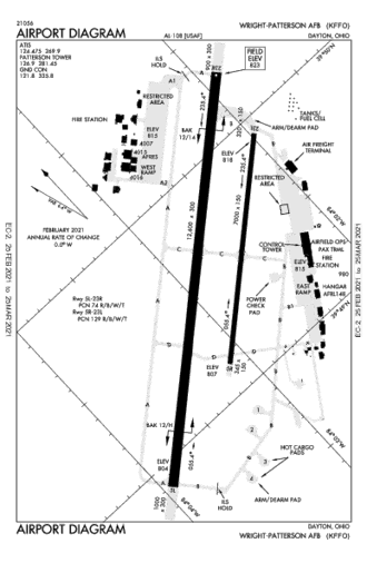
Wright-Patterson AFB, Ohio, United States (45433)
  
| Lat/Lng: | 39° 49' 33.49" N / 84° 2' 45.97" W
39.825969 / -84.046103 |
|---|
| Elevation: | 823'ft / 251mMSL |
|---|
| Declination: | W004° |
|---|
| ID / ICAO: | KFFO |
|---|
| FAA: | FFO |
|---|
| Runways: | 2 |
|---|
| Longest: | 05L-23R
Asphalt 3,830m / 12,566ft |
|---|
| | |
|---|
| Airport use: | Military, Private, Permission required |
|---|
| Controlled: | Yes |
|---|
(Edited 2014-05-21) [ Edit disabled ]
| ATIS: | 124.47 |
|---|
| Ground: | 121.8 |
|---|
| Tower: | 126.9 |
|---|
| Approach: | 118.85 |
|---|
[ Edit disabled ]
| SPRINGFIELD VOR-DME | 10.7 NM |
| SGH | freq: 113.20 |
E 86° |
| DAYTON VOR-DME | 22.8 NM |
| DQN | 114.50 |
NW 305° |
| MIDWEST VOR-DME | 30.3 NM |
| MXQ | 112.90 |
SE 154° |
| ROSEWOOD VORTAC | 31.9 NM |
| ROD | 117.50 |
N 0° |
| RICHMOND VORTAC | 42.4 NM |
| RID | 110.60 |
W 263° |
|
| XENIA NDB | 9.8 NM |
| XEN | freq: 395 |
SE 141° |
| CLARK CO NDB | 14.5 NM |
| CCJ | 341 |
E 76° |
| BRUNY NDB | 15.4 NM |
| AT | 315 |
W 275° |
| ONIDA NDB | 22.6 NM |
| MW | 223 |
SW 220° |
| ONIDA NDB | 22.6 NM |
| MW | 223 |
SW 220° |
| ONIDA NDB | 22.6 NM |
| MW | 223 |
SW 220° |
| AIRBO NDB | 28.2 NM |
| IL | 407 |
SE 144° |
| HOOK FLD NDB | 31.1 NM |
| HKF | 239 |
SW 223° |
| LONDON NDB | 31.7 NM |
| UYF | 263 |
E 76° |
| CUBLA NDB | 33.9 NM |
| HW | 299 |
S 164° |
| COURT HOUSE NDB | 38.1 NM |
| CSS | 414 |
SE 114° |
| HAMILTON NDB | 42.0 NM |
| HAO | 260 |
SW 221° |
| CINCINNATI-BLUE A NDB | 43.9 NM |
| ISZ | 388 |
SW 204° |
| BOUTN NDB | 44.6 NM |
| BU | 230 |
E 90° |
| BOUTN NDB | 44.7 NM |
| BU | 230 |
E 90° |
| MADEIRA NDB | 44.8 NM |
| MDE | 379 |
S 201° |
| OXFORD NDB | 44.8 NM |
| OXD | 282 |
SW 240° |
| MARYSVILLE NDB | 46.1 NM |
| MRT | 403 |
NE 53° |
| FULER NDB | 48.1 NM |
| OS | 515 |
E 69° |
| RUSHSYLVANIA NDB | 48.1 NM |
| RUV | 326 |
NE 24° |
|
| Dimensions: | 3830.2 x 91.4m 12566' x 300'ft |
|---|
| Surface: | Asphalt |
|---|
| Edge Lights: | High intensity |
|---|
| Runway 05L [A] | Runway 23R [B] |
|---|
| Heading: | 052°MH 048°TH | 232°MH 228°TH |
|---|
Lat:
Lng: | 39° 48' 53.61"N
84° 3' 54.54"W | 39° 50' 15.42"N
84° 1' 52.78"W |
|---|
| ALS: | ALSF-I | ALSF-I |
|---|
| TDZ: | Yes, lighted | |
|---|
| Dimensions: | 2124.3 x 45.7m 6969' x 150'ft |
|---|
| Surface: | Asphalt |
|---|
| Edge Lights: | Medium intensity |
|---|
| Runway 05R [A] | Runway 23L [B] |
|---|
| Heading: | 052°MH 048°TH | 232°MH 228°TH |
|---|
Lat:
Lng: | 39° 49' 8.91"N
84° 3' 5.94"W | 39° 49' 54.35"N
84° 1' 58.29"W |
|---|
|
|

 Australia
 Brazil
 Canada
 France
 Germany
 India
India Italy
Italy Russia
 Spain
Spain UK
UK USA
USA


